

easyAIS
default

Beschreibung von easyAIS
“easyAIS” is a free AIS real-time vessel positioning tool designed for the use on AIS receivers with WiFi connectifity.
The Automatic Identification System (AIS) is a maritime transponder/receiver system defined by the IMO (International Maritime Organisation).
AIS main objectives are to improve maritime safety and to protect the maritime environment.
Practically, AIS
•assists collision avoidance (AIS ship-to-ship)
•enables ports and coastal states to identify ships and to manage and supervise the traffic in their waters (AIS Coast station, VTS)
•helps to resolve the difficulty of identifying ships when not in sight (e.g. at night, in radar blind arcs or shadows or at distance)
By means of special VHF transceiver cruise data will be exchanged in short terms automatically. The treatment has a worldwide standard and runs every where. So vessels who use AIS devices from different companies will „see“ each other.
AIS enables to view over obstacles and complements radar. Acording to the antenna instalation hight an AIS station has got a transmission range about 20 to 30 nautical miles.
With the “easyAIS” app by the Weatherdock AG, all AIS targets within range are displayed relative to the user's position.
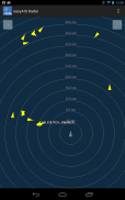
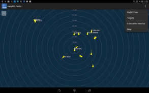
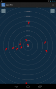
Main screen after starting the app is a virtual radar screen showing the AIS targets in relative position to you
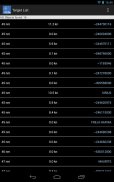
Just tapping the screen on an AIS target brings you to a list with all transmitted details of this target, e.g. GPS position, corse over ground, speed over ground, ship name, call sign, length, width, draft, port of registration …
“easyAIS” works by getting AIS data via WiFi from the AIS receiver or transceiver aboard. Without a running AIS
Notice:
“easyAIS” should not be used for navigational purposes!"EasyAIS" ist ein kostenloser AIS Echtzeit Schiffsortungssysteme Werkzeug für den Einsatz auf AIS-Empfänger mit WiFi connectifity konzipiert.
Das Automatic Identification System (AIS) ist ein maritimer Transponder / Empfänger-System von der IMO (International Maritime Organisation) definiert.
AIS Hauptziele sind die Sicherheit des Seeverkehrs zu verbessern und die maritime Umwelt zu schützen.
Praktisch, AIS
• Assists Kollisionsvermeidung (AIS Schiff-zu-Schiff)
• ermöglicht Ports und Küstenstaaten die Schiffe zu identifizieren und zu verwalten und zu überwachen den Verkehr in ihren Gewässern (AIS Coast Station, VTS)
• hilft, die Schwierigkeiten bei der Identifizierung von Schiffen zu lösen, wenn nicht in Sicht (zB in der Nacht, in der Radar-blinden Bögen oder Schatten oder im Abstand)
Durch spezielle VHF-Transceiver cruise Daten werden in kurzen Laufzeiten automatisch ausgetauscht werden. Die Behandlung hat einen weltweiten Standard und läuft überall. So Schiffe, die AIS-Geräte verwenden aus verschiedenen Unternehmen "sehen" sich gegenseitig.
AIS ermöglicht den Blick über Hindernisse und ergänzt Radar. Acording zur Antenne instalation Höhe ein AIS-Sender hat eine Reichweite etwa 20 bis 30 nautische Meilen bekam.
Mit dem "easyAIS" app von der Weatherdock AG werden alle AIS Ziele in Reichweite erscheint bezogen auf die Position des Benutzers.
Hauptbildschirm nach dem Start der App ist eine virtuelle Radarschirm zeigt die AIS-Ziele in der relativen Position zu Ihnen
Nur auf den Bildschirm tippen auf ein AIS-Ziel bringt Sie zu einer Liste mit allen übermittelten Daten dieses Ziels, z. B. GPS-Position, corse über Grund, Geschwindigkeit über Grund-, Schiffs-Name, Rufzeichen, Länge, Breite, Tiefgang, Hafen Anmeldung ...
"EasyAIS" funktioniert, indem sie AIS-Daten via WiFi vom AIS-Empfänger oder Transceiver an Bord. Ohne laufenden AIS
Hinweis:
"EasyAIS" sollte nicht für Navigations-Zwecke verwendet werden!


